
全部拍賣 / Books, Maps & Manuscripts / France - County of Poitou: Vienne

France - County of Poitou: Vienne
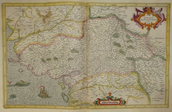
Copper-engraved old map of Poitou in intaglio, hand-colored, by Mercator, published in 1633 in the Mercator-Hondius atlas. Here, at the top right, is the title cartouche with scrolls, adorned with two mascarons and garlands of fruit. At the bottom, a second cartouche bears the scale “Miliaria Pictonica communia,” surmounted by a fleur-de-lis. The sea, engraved with moiré waves and named “Oceanus Aquitanicus,” is animated by a sea monster and a three-masted ship bearing a red flame. A shoal is indicated by the Latin inscription “Arquaigne scopulus sub mari tribus ul[-]nis.” The coast extends from the Loire estuary to that of the Gironde, with the islands of Noirmoutier, Île d’Yeu (“Lisle de Dieu”), Île de Ré and Île d’Oléron. Inland appear Poitiers, Niort, Luçon, Fontenay, Châtellerault, Loudun and Thouars, as well as Nantes, Angers, La Rochelle, Saintes, Angoulême and Limoges. Forests are represented by clumps of trees colored green, including the “Mouliere sylva,” and the Poitevin Marsh is indicated under the name “Marays.” The provincial boundaries are outlined with pink, yellow and green borders, and the graduated border bears the four cardinal points in Latin. The neighboring provinces are named: Brittany, Anjou, Touraine, Berry, Limousin, Angoumois, Saintonge, Aunis, Haute and Basse Marche. The reverse side bears the French text devoted to Poitou (pages 309 and 312), with a woodland-engraved illuminated initial. This text mentions the Pierre levée of Poitiers, on which travelers engraved their names, and cites among them Gérard Mercator and Abraham Ortelius. - Dimensions: on the sheet: 56 x 47.5 cm; on the map’s face: 46.9 x 35.3 cm - Condition: Very good overall for a map of this period. There is a foxing mark on the right margin of the first page. See photos for more details. Atlas Mercator-Hondius - The atlas called “Mercator-Hondius” reprises the work of Gérard Mercator, whose copperplates were bought back by Jodocus Hondius in 1604. This French edition of 1633 is signed by his son Henricus Hondius and his son-in-law Joannes Janssonius, who augmented it with new maps. Gérard Mercator – Gérard Mercator (Rupelmonde, 1512 – Duisburg, 1594) was a Flemish geographer, mathematician and engraver. Trained at the University of Leuven, he settled in Duisburg in 1552. In 1569 he published the world map according to the projection that bears his name. His maps of France appeared in 1585 in the Galliae tabulae geographicae, the first part of a collection he named the “Atlas.” After his death, the copperplates were acquired in 1604 by Jodocus Hondius, in Amsterdam. His sons and his son-in-law Johannes Janssonius continued the publication, including the French edition of 1633.
估價:$222.59
前往拍賣頁查看所有物品來自Catawiki或Books, Maps & Manuscripts
估價:
$222.59
類似物品






類似物品的拍賣結果

IRON MAIDEN, affisch, "No prayer on the road", special guest Anthrax
10/26/2026
$77.36
估價: $100.74

ASTRONOMI, Amédée Guillemin: Le ciel. Notions élémentaires d'astronomie
10/26/2026
$70.33
估價: $100.79

PROPAGANDA, 2 vol: E.V. Lucas - George Morrow, In gentlest Germany
10/26/2026
$40.19
估價: $100.79

讓您的拍賣觸及全球收藏家!
立刻發佈上架